
Airspace and Navigation
At first glance, the National Airspace System (NAS) of the United States is a complex web of different types of airspace, each with its own restrictions, limitations, and unique requirements. For remote PICs to safely and legally operate in the NAS, they need to become intimately familiar with the various different airspace categories, including which ones to avoid, which are open for use, and the specifics for those that fall somewhere in between. Aeronautical charts are probably the best source of airspace information. You can access them online or through phone or tablet applications as well as have hard copies in hand. The key is to have current, up-to-date charts so you’re not missing any recent changes. In addition, you will need to check all pertinent Notices to Airmen (NOTAMs) prior to each operation.
Knowing Where You Can Fly
Drone pilots can fly in controlled and uncontrolled airspace. The requirements for operations are different depending on the airspace type in which you plan to fly. There are a number of resources that can help you determine where you can legally fly and if you need an authorization before doing so:
- B4UFLY service: The FAA has approved four companies to provide B4UFLY services through desktop and mobile applications. Go to the FAA B4UFLY page at faa.gov/uas/getting_started/b4ufly, then choose and download the one of the FAA approved drone flying app to your favorite device. This service provides situational awareness to recreational flyers and other drone users with real-time information about airspace restrictions and other information to help you fly safely.
- Low Altitude Authorization and Notification Capability (LAANC) system, which also provides real-time information about airspace restrictions and near-real-time airspace authorizations. You can also apply for airspace authorizations through LAANC.
- Study airspace using resources such as this book and the Pilot’s Handbook of Aeronautical Knowledge. (This is available on the FAA website or from the retailer of your choice.)
- Learn about airspace restrictions and how to find out about them. In addition to the coverage of the topic in this book, the FAA provides an overview of these restrictions at faa.gov/uas/getting_started/where_can_i_fly/airspace_restrictions.
- Learn how to read aeronautical charts. While this book will provide you with a comprehensive understanding of how to read these maps, you may also want to download a copy of the Aeronautical Chart Users’ Guide, available online for free, compliments of the FAA .
Once you have gained the necessary skills to identify where you can legally and safely fly your drone, you are ready to actually go out into the field to get airborne.
Aeronautical Charts
You will use several types of charts as a remote pilot. The sectional chart is the one used most frequently because at roughly 8 nautical miles per inch, it affords sufficient detail for navigation by landmarks while retaining a manageable size. There are 38 sectionals covering the continental United States, plus three Canadian provinces in the Northeast, 16 more for Alaska, and one for Hawaii. New charts are published every six months. Before using an expired chart, consider that an average of 128 changes are made per charting cycle.
Sectionals show roads, freeways, railroads, power lines, lakes, rivers, terrain contours, and populated areas. Airports shown on sectional charts include public, private, military, and those to be used only in an emergency. Boundaries of controlled airspace are indicated by color tint and a variety of symbols. Before you take your written test, become familiar with the sectional chart legend, because knowing your way around a sectional will play a major role in the exam.
Terminal area charts are published for the busiest airports (those with Class B airspace, discussed later in this lesson). Their 4-miles-per-inch scale makes them quite detailed, and properly so: you must know where you are when flying in congested airspace. Revised charts are issued every six months.
The Chart Supplement is issued every 56 days and includes information not found in any other publication. In Lesson 2, I noted that the Chart Supplement includes an Aeronautical Chart Bulletin. Now look at the chart revision frequencies mentioned above—the shortest is six months. What if a cell tower has been erected since the last issuance of the sectional chart you are using? What if an airport shown as non-towered on your chart now has an operating control tower? What if the control tower is shown on your chart, but the tower frequency has changed? Unless you refer to the Chart Supplement’s Aeronautical Chart Bulletin, you will be flying blind. Every year, pilots get themselves into trouble by using out-of-date charts. Don’t be one of them.
Having said that, there is no provision in Parts 101 or 107 that requires you to carry any charts at all, recent or outdated. There are some online sources that you can refer to. Keeping in mind that web addresses come and go without notice, here are some useful URLs: faa.gov/air_traffic/flight_info/aeronav/digital_products is the official FAA source. Unfortunately, because sectionals are vast and consumer-level printers are small, you have to print out several individual charts and tape them together. Among unofficial sources are skyvector.com, vfrmap.com, and 1800wxbrief.com. You can “fly” your proposed trip using Google Earth, checking out visual checkpoints along the way, and you can look at the area around your destination by using the “Airports” page under 1800wxbrief.com.
Geographical Coordinates
To be able to better use navigation charts, you should be familiar with latitude and longitude. You will also use latitude-longitude coordinates with some advanced radio navigation systems such as GPS, so a brief explanation is in order.
Figure 3-1 shows parallels of latitude marching upward from the Equator (0° latitude) to the Poles (90° North or South latitude). If you slice a globe along lines of latitude, the slices get progressively smaller toward the poles, so distance measurements along latitude lines are useless.
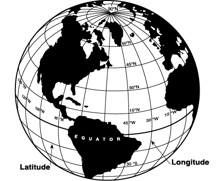
Figure 3-1. Meridians and parallels.
Lines of longitude are called meridians and divide the earth from pole to pole, with the 0° meridian passing through Greenwich, England. Meridians are numbered eastward across Europe and Asia and westward across the Atlantic Ocean and the Americas until the 180° meridian is reached in mid-Pacific. The continental United States lies roughly between 70° and 125° West longitude and between 26° and 49° North latitude. Meridians are Great Circles: if you slice a globe along meridians, all of the slices will be the same size. All meridians are the same length: 10,600 nautical miles from pole to pole, and 60 nautical miles per degree.
Each degree is further divided into 60 minutes, and this makes it possible to measure distance accurately: one minute of latitude equals one nautical mile when measured along a line of longitude toward either pole. Minutes are identified by a single tick—for example, 25′ represents 25 minutes. Minutes are divided further into 60 seconds, which are shown by a double tick (e.g., 25”).
As you look at your aeronautical chart, lines of longitude and latitude are at right angles. As you look at a globe, however, lines of longitude converge toward the poles. Because there is some unavoidable distortion of scale between the bottom and the top of an aeronautical chart, you should make course measurements as close as possible to the mid-latitude portion of the chart.
On the excerpt of the Seattle sectional chart (see Appendix D), find the Easton State airport (A). Count up (north) 15 minutes from the latitude line marked 47° to find the latitude of Easton State. Each little tick mark moving upward is a minute, with the larger tick indicating 10 minutes. Count left (west) 11 minutes from the longitude line marked 121° to find the longitude of Easton State. Its geographic position is 47° 15′ 15″ north, 121° 11′ 15″ west. You do not need to be any more accurate than the nearest minute to locate an airport using latitude and longitude. The geographic position of all airports is found in the Airport/Facility Directory.
Time
The measurement of time is an integral part of air navigation. Before leaving the discussion of longitude and the 0° meridian, the subject of time zones and time conversions should be covered. The only rational way to have flight times and weather information apply across the country and around the world is to have a single time reference. That reference is the time at Greenwich, England (on the 0° line of longitude). Once referred to as Greenwich Mean Time, the time standard is now called Universal Time Coordinated (UTC). Each 15° of longitude east or west of Greenwich marks a one-hour time difference. Figure 3-2 shows the time differences across the United States with a legend for time conversion to and from Universal Time Coordinated, or Zulu time. Zulu is the phonetic identifier for the letter Z; in the 24-hour clock system, UTC is shown as 0800Z, 2200Z, etc. You should become familiar with time zone conversions for your area of operations.
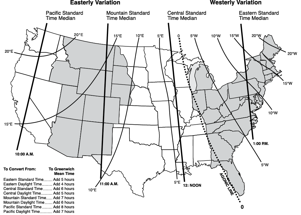
Figure 3-2. Time conversion (also showing magnetic variation).
Air traffic control and flight service station personnel use Zulu time and will be reluctant to do time conversions for you. If you are planning a departure for 1800 local time and there is a forecast for thunderstorms after 2100Z at your mission location, you will have to know time conversion to be able to relate that to your estimated time of flight. As a new pilot, you will probably stay within one time zone or possibly travel between two time zones. Just remember that, for example, you live in the “plus 5” time zone (plus 4 in the summer), and conversions will come easily to you.
Statute and Nautical Mile Scale
Navigators on the sea or in the air find the use of nautical miles for distance measurement convenient, because a nautical mile is 6,000 feet (really 6,080, but that complicates things) and is also one minute of latitude. When you counted up 15 minutes to locate the latitude of Easton State airport, you counted up 15 nautical miles. You will find mileage scales for both nautical and statute miles on aeronautical charts. The FAA uses nautical miles for all distance measurements except visibility, which is measured in statute miles. Airspeed is usually referred to in knots (nautical miles per hour) only or in knots and miles per hour (MPH); you can find conversion calculators online or via various applications (or you can buy a flight computer). Winds are always given in knots, so you must be sure that you are dealing with like units when flight planning.
Magnetic Variation
Aviation has often followed the nautical path on a range of things but most notably in navigation. One such borrowed tool that has been used for aerial navigation for some time is the magnetic compass. It is a very effective means for determining which way is north and how to navigate from point A to point B, at least in most places on Earth. However, remote PICs must become aware that compasses and magnetic headings (used by crewed aircraft pilots) align with the Magnetic North Pole, which is in Northern Canada (and moves over time; see Figure 3-3). Thus, you should be aware that lines of latitude and longitude on charts are neatly perpendicular and relate to the True North Pole. The easiest way to keep these apart in your mind is to think of the True North Pole as where Santa lives, while the Magnetic North Pole is where your compass points.
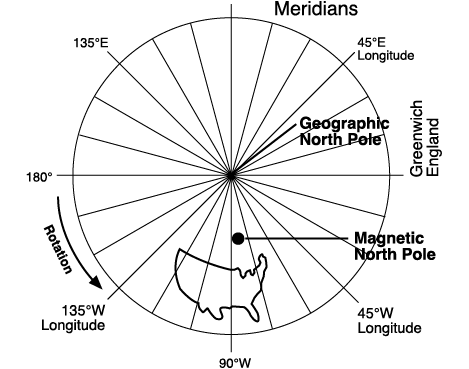
Figure 3-3. Magnetic and True North Poles.
You must take the variation between true north and magnetic north into account when interpreting air traffic headings and directions as well as things such as airport runway numbers. Additionally, when you receive aviation weather products, you need to realize that headings of winds are in reference to true north. However, winds provided directly from an air traffic control tower are in magnetic. In much of the United States, the difference between true and magnetic is not significant, but in certain areas it is huge (e.g., in Alaska).
Figure 3-4 shows isogonic lines, or lines of equal magnetic variation, across the continent. Along the line that passes through Chicago and Key West, a pilot looking toward the True North Pole will also be looking toward the magnetic North Pole, and there will be no variation. That line of zero variation is called the agonic line. The angle between true and magnetic north increases east or west of that line. A pilot in Los Angeles who measures a course line on an aeronautical chart in relation to the longitude lines (or true north) must subtract 14° from that true course to get a magnetic course (“East is least”), while a pilot in Philadelphia will add 10° (“West is best”). You can determine the true course by using your navigation plotter.
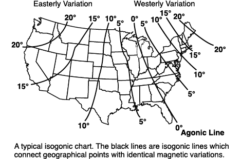
Figure 3-4. Isogonic lines.
The variation on your sectional chart is almost certainly out-of-date. The isogonic lines are only updated every three years or so. The next best source for variation is a current Chart Supplement.
Correcting for Wind Drift
Figure 3-5 shows the effect of wind drift on an aircraft’s flight path if no corrective action is taken. The wind correction angle necessary to offset the wind drift will allow the aircraft’s track over the ground to agree with the planned course. Determining wind correction angle with a known wind direction, wind velocity, true course and true airspeed is a trigonometry problem. Because sUAS operations currently must be within visual line-of-sight (VLOS), wind correction will be made visually; thus, the calculations made by crewed aircraft pilots for long-range flights is generally unnecessary. Beyond VLOS flights (when they eventually are authorized to occur or for those with a waiver) will employ relatively sophisticated navigation systems that will assist in or deal with necessary wind corrections.
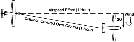
Figure 3-5. The effect of wind.
Ground Speed vs. Airspeed
When you drive your automobile for one hour at 60 miles per hour, you can be fairly certain that you will travel 60 miles during that hour. In flight, whether or not one hour at 60 miles per hour will cover 60 miles will be determined by the wind. If you somehow manage to get airborne under control and are flying into a 60 MPH headwind with an airspeed of 60 MPH, you are not going to make it out of sight of the launch site: your speed over the ground will be zero. This is an extreme example, although pilots in the Great Plains states have plenty of stories about airplanes “flying” in strong winds that prove that it can happen. You can actually “fly” backwards if the winds are stronger than your forward speed! Though these tales are certainly entertaining, you need to develop an understanding of the airspeed/ground speed relationship on a more normal basis.
First, forget the comparison with the automobile and standardize all speed measurements in knots: the National Weather Service provides wind velocity information in knots and confusion will result if you mix units of measurement. Although much of aviation has adopted knots for airspeed indication, that does not appear to be the case with many sUAS manufacturers who report capabilities in MPH or kilometers per hour (KPH). Often the telemetry provided to you via your ground controller will not be in knots either. Remember that your true airspeed will increase 2% per 1,000 feet of altitude increase. This means that the speed at which a sUAS moves through the air (and along the ground, in no wind conditions) increases as either the sUAS climbs or when you choose an area of operation at a higher altitude.
Keep in mind the effects of wind on speed when determining how far is too far in regards to the distance between your sUAS and the intended landing zone. In high wind conditions, it is possible for an aircraft to get far enough away that it will not have enough battery power to make it back to you. Pay careful attention to battery power levels throughout the flight.
Chart Reading
In other lessons, you will learn how to look at your aeronautical chart to determine radio frequencies and airspace designations. Bookmark the Seattle sectional chart excerpt in Appendix D; refer to it and its legend as you read this section. The importance of knowing the height of terrain and obstructions is evident. Notice that in each rectangle formed by lines of latitude and longitude there is a large blue number with an adjacent smaller number. This represents the height above mean sea level of the highest terrain or man-made obstruction within that rectangle, in thousands and hundreds of feet plus a safety margin. 83, for instance, means that you will clear the highest obstacle if you fly at 8,300 feet or higher. The heights of specific terrain features are indicated by a dot and the measured altitude; the altitude of the highest terrain within a latitude-longitude block is in large print—note Mount Rainier at the bottom of the chart and Mount Stuart at 47° 28ʹ N 120° 54ʹ W (see letter “N” west of airport H). You will notice that the highest obstacle is at least 100 feet below the 83 if it’s a man-made obstacle, and at least 300 feet below if it’s a natural obstruction. This is for added safety.
It is important to remember that most altitude information that is available via the flight controller is relative to where the sUAS took off, not in relation to mean sea level. Therefore, it is helpful to have an idea of the elevation of the location at which you are flying. This can be determined using aeronautical charts or online mapping applications.
Man-made obstructions such as radio and television towers have two numbers adjacent to them. The top number (in bold italics) is the height of the top of the obstruction above mean sea level, and is the most meaningful number to you in choosing an altitude in that area. The number in parentheses is the actual height of the structure. Towers that are more than 1,000 feet in height (which usually require supporting guy wires that are virtually invisible) have a special symbol as shown in the chart legend. The dot at the base of the symbol represents the exact location of the obstruction. The group obstruction symbol (two symbols close together) means that there are two or more towers. There are several obstruction symbols, both single and group, north and west of Seattle-Tacoma airport. Wind farms are also depicted on sectional charts with an unmistakable symbol.
Freeways, highways, and railroads are excellent references. Notice that major freeways are identified with their route numbers—Interstate 90 crosses the chart from Seattle to the lower right corner. You can often orient yourself by noticing an interchange or an obvious jog in a road, or by the relationship between a road and some other physical feature. Because power lines are centered in large right-of-way areas, they are just as useful as highways—you can see the cleared right-of-way much further than you can see the power lines themselves.
Do not rely on the city limits depicted so clearly in yellow on sectional charts; from the air, city limits are impossible to identify. This is particularly important if the city in question has restrictions on sUAS use (e.g., No Drone Zones).
Changes in elevation are depicted with contour lines. On the sectional chart excerpt, you can see how tightly packed the contour lines are in the Cascade Mountains. Notice the interval between contour lines. The lines are every 500 feet on sectionals. Mountain passes are indicated by a pair of back-to-back parentheses—for example, look about an inch to the left of airport A on the sectional chart excerpt to find Stampede Pass.
Always check your chart for markings that indicate parachute jumping areas (airport G), wind turbines, and low-lying cables across rivers and ravines. (Running into a skydiver or a power cable can ruin your whole day!) Where jumping is indicated, check the Chart Supplement for details; the operators will usually announce the position of the jump aircraft and when jumpers begin their dive.
Airport and Navigation Aid (NAVAID) Identification
Aeronautical charts, as well as other sources, utilize an identification paradigm that can be thought of as a short name or abbreviation for a particular airport or NAVAID. This naming convention entails three letters (or four letters when using the international version [for airports only]; for most locations in the US, this comprises the regular three-letter abbreviation with a “K” prefix, which denotes that the location is within the lower 48 US states).1 Many of these identifiers will make sense to the non-aviator. For example, San Diego International Airport is denoted by the letters SAN (or KSAN internationally). Some other identifiers, however, are not as obvious—the Auburn, Washington, airport is identified as S50 (no K is required for these odd arrangements of letters and numbers). The same abbreviation system is used for NAVAIDs.2 The main reason the four-letter arrangement exists is to distinguish between airports and NAVAIDs, which, in theory, could use the same letters although each was in a different geographic location. An example of this is in Billings, Montana, where both the NAVAID and the airport use the identifier BIL, but the NAVAID is 4 miles west of the airport. In this case, using the four-letter identifier allows you to be clear which you are referring to: BIL (the NAVAID) or KBIL (the airport). For more information about the different kinds of navigation facilities, refer to the AIM. These do not mean much to sUAS operations other than that crewed aircraft and ATC may use them in their communications, and they may be useful in relating information about aircraft location.
Airspace
As you plan a flight, you know that the ability to maneuver in three dimensions makes you responsible for being aware at all times of your position, both geographic and vertical. You must ensure that you are always in compliance with the airspace regulations. These regulations are intended to keep airplanes safely separated. “See and be seen” is the basis of safe operations in the National Airspace System.
Controlled vs. Uncontrolled Airspace
You will encounter the terms “controlled airspace” and “uncontrolled airspace” frequently, and you must not assume that flight in controlled airspace means that Big Brother will be watching you to detect violations, or that uncontrolled airspace is the Wild West for flight. For the remote pilot, controlled and uncontrolled airspace refer to the possibility of being subject to air traffic control. (For crewed aircraft, the difference is in minimum weather requirements, but for sUAS such requirements are currently the same regardless of airspace type). Controlled airspace is where aircraft of all types may be subject to ATC. For example, in Class E airspace, crewed aircraft are not required to contact ATC or be subject to its control unless the aircraft is on an instrument (IFR) flight plan. However, all aircraft in Class D must communicate with ATC. In uncontrolled airspace—referred to as Class G airspace—no one is subject to ATC.
Controlled airspace includes Class A, B, C, D, and E airspace (Figure 3-6). Look at the sectional chart excerpts in Appendix D and notice the blue and magenta tints—they represent the horizontal boundaries of controlled airspace (Class A airspace begins at 18,000 feet MSL and that is as high as a sectional chart goes). Blue is only used where it abuts Class G airspace, however.
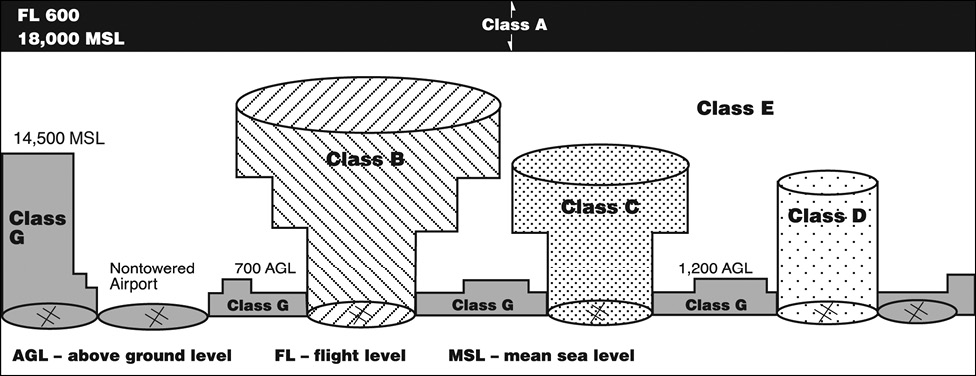
Figure 3-6. Airspace classification.
At airports with instrument approach procedures (a means to permit crewed aircraft to land in bad weather), controlled airspace can start at the surface—each of these situations will be covered in detail later. Figure 3-6 will give you an idea of what to expect. As you can see, most controlled airspace is Class E.
On the Seattle sectional chart excerpt (Appendix D), follow the 072 radial (the eastbound blue highlighted line) extending from the Seattle VORTAC (C) (a radio navigation aid used by crewed aircraft); it is the V-120 airway (airways are “highways in the sky”—think of this airway as Interstate 120 for crewed aircraft). Until you fly by the “powerhouse” depicted and cross the magenta line, you are in Class E airspace at or above 700 feet AGL. The fact that the magenta tint fades in the direction of Seattle indicates that this floor applies to the entire area surrounded by the tint.
Note that the floor of a Victor airway (V-120 in this example) is 1,200 feet above ground level (with some exceptions) and the ceiling is 18,000 feet above mean sea level.
After you pass the magenta line flying eastward along the 072-degree radial, the floor of Class E airspace becomes 1,200 feet above the ground (no shading) and that situation remains until you get to the magenta dashed line around the Wenatchee VORTAC.
Although you will not find any on the sectional chart excerpt, there are places where Class G airspace extends from the surface to 14,500 feet mean sea level (MSL). Look for the solid edge of a blue vignetted line—the floor of controlled airspace on the shaded side is 1,200 feet above the surface, but the airspace on the solid-edge side is uncontrolled all the way up to 14,500 MSL.
Class A Airspace
Class A airspace exists from 18,000 feet MSL to Flight Level 600 (all altitudes above 18,000 feet are called Flight Levels; FL230 is 23,000 feet, more or less). Not only are sUAS not permitted in Class A, they probably couldn’t get up there even if they were allowed. Only large-scale UAS (e.g., military types) can fly that high.
Class B Airspace
The most important thing to remember about Class B airspace is that you cannot operate within its boundaries unless you have a specific authorization from ATC to do so. Class B airspace (Appendix D) is shown on sectional charts by solid blue circles or arcs; each segment within the airspace is identified with what looks like a fraction. On the sectional chart excerpt, the top of the fraction is 100, indicating that the top of Seattle’s Class B airspace is 10,000 feet MSL.
The bottom of the fraction is the floor of the airspace in hundreds of feet. East of Bremerton National Airport (D) you can fly beneath the Class B airspace at 5,500 feet, and west of Bremerton the Class B airspace does not exist. Note that the floor of Class B airspace over Seattle-Tacoma International Airport is the surface of the airport itself.
Considering that student pilots of crewed aircraft are prohibited from operating to or from many of the following super-busy airports within Class B airspace, you probably won’t be able to operate sUAS near them either:
Arizona:
- PHX / KPHX—Phoenix Sky Harbor International
California:
- LAX / KLAX—Los Angeles International
- NKX / KNKX—Marine Corps Air Station Miramar
- SAN / KSAN—San Diego International/Lindbergh Field
- SFO / KSFO—San Francisco International
Colorado:
- DEN / KDEN—Denver International
Florida:
- MCO / KMCO—Orlando International
- MIA / KMIA—Miami International
- TPA / KTPA—Tampa International
Georgia:
- ATL / KATL—Hartsfield–Jackson Atlanta International
Hawaii:
- HNL / PHNL—Daniel K. Inouye/Honolulu International
Illinois:
- ORD / KORD—Chicago O’Hare International
Kentucky:
- CVG / KCVG—Cincinnati/Northern Kentucky International
Louisiana:
- MSY / KMSY—Louis Armstrong New Orleans International
Maryland:
- ADW / KADW—Joint Base Andrews*
- BWI / KBWI—Baltimore/Washington International*
Massachusetts:
- BOS / KBOS—General Edward Lawrence Logan International
Michigan:
- DTW / KDTW—Detroit Metropolitan Wayne County
Minnesota:
- MSP / KMSP—Minneapolis–Saint Paul International/Wold–Chamberlain Field
Missouri:
- MCI / KMCI—Kansas City International
- STL / KSTL—St. Louis Lambert International
Nevada:
- LAS / KLAS—Las Vegas–McCarran International
New Jersey:
- EWR / KEWR—Newark Liberty International
New York:
- JFK / KJFK—New York–John F. Kennedy International
- LGA / KLGA—New York–LaGuardia
North Carolina:
- CLT / KCLT—Charlotte Douglas International
Ohio:
- CLE / KCLE—Cleveland Hopkins International
Pennsylvania:
- PHL / KPHL—Philadelphia International
- PIT / KPIT—Pittsburgh International
Tennessee:
- MEM / KMEM—Memphis International
Texas:
- DFW / KDFW—Dallas/Fort Worth International
- HOU / KHOU—Houston–William P. Hobby
- IAH / KIAH—Houston–George Bush Intercontinental
Utah:
- SLC / KSLC—Salt Lake City International
Virginia:
- DCA / KDCA—Ronald Reagan Washington National*
- IAD / KIAD—Washington Dulles International*
Washington:
- SEA / KSEA—Seattle–Tacoma International
*Note: The Washington, D.C., area is a “No Drone Zone.” For more information, see: www.faa.gov/uas/resources/community_engagement/no_drone_zone.
Although all Class B primary airports have control towers, they do not have Class D airspace.
Class C Airspace
The Seattle sectional chart excerpt that has been included in Appendix D for your use does not contain any Class C airspace; however, Figures 3-7a and 3-7b show excerpts of the Spokane and Whidbey Island areas, where both Spokane International and Fairchild Air Force Base are in Class C airspace. Figure 3-7b shows the Class C airspace at the Whidbey Island Naval Air Station. Note how many satellite airports are located beneath the outer rings at both Spokane and Whidbey. The horizontal boundaries of Class C airspace are shown by solid magenta circles. Remember that you need authorization to fly sUAS in Class C airspace.
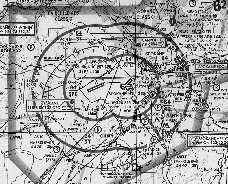
Figure 3-7a. Spokane International and Fairchild Air Force Base Class C airspace.
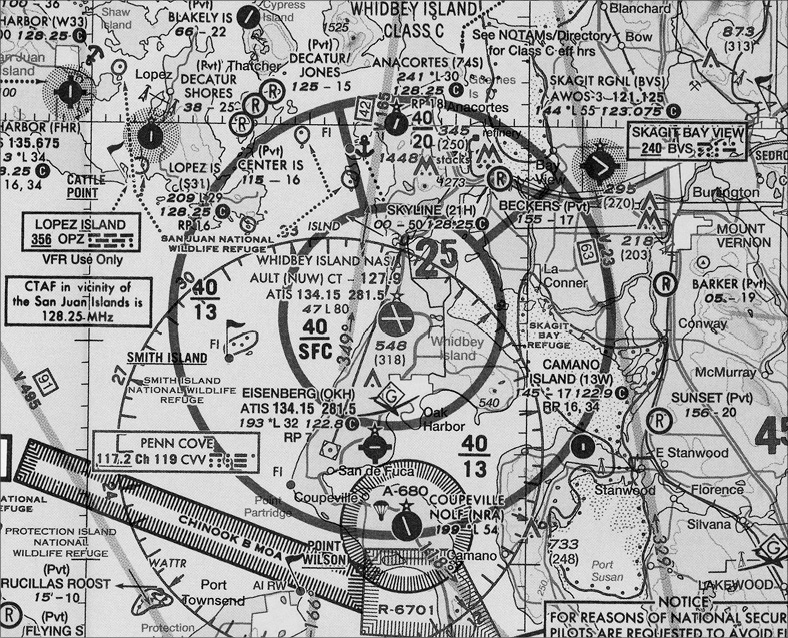
Figure 3-7b. Whidbey Island Class C airspace.
Many Class C areas do not operate 24 hours a day. Where operation is part-time, check the panel on the back of the sectional chart or, as advised by a chart notation near the airspace, check the Chart Supplement for operating hours and the type of airspace the Class C reverts to when it is not in effect.
Each segment within the airspace is identified with what looks like a fraction. In Figure 3-7b, the top fraction is 40, indicating that the top of Whidbey Island’s Class C airspace is 4,000 feet; you can fly over it at 4,500 feet without talking to anyone. The bottom of the fraction is the floor of the airspace in hundreds of feet—1,300 or 2,000. Note that the floor of Class C airspace over Whidbey Island Naval Air Station is the surface of the airport itself.
Class D Airspace
Class D airspace exists whenever a control tower is in operation, except for airports with Class B or C airspace (which include tower functions). Class D airspace imposes a requirement for ATC authorization for sUAS operations. What are the dimensions of Class D airspace? The horizontal boundary is shown on charts with a blue dashed line (the airport symbol is blue when there is a tower at the airport); the vertical extent is from the airport elevation to 2,500 feet above the airport (or the base of a different kind of airspace above). Figure 3-8 shows a nice cylindrical shape for clarity, but actual dimensions will vary widely. The elevation of the top of the airspace to the next highest hundred feet is shown in a little square box near the airport symbol. (Look at any tower-controlled airport except Seattle-Tacoma to check this. Sea-Tac shows −30 because it sits on a plateau above Puget Sound and the top of its Class D airspace is the 3,000-foot floor of the associated Class B airspace.)
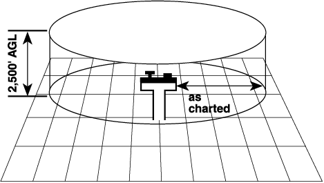
Figure 3-8. Class D airspace.
The shape of Class D airspace varies with local conditions. There will be extensions to provide protected airspace for incoming instrument flights, cutouts to exempt satellite airports from the communication requirements, or shelves to allow pilots to fly into and out of airports beneath the edges of the airspace (Figure 3-9). If an extension is 2 miles or less (still shown with blue dashed lines), you need tower permission to fly in that airspace; if the extension is more than 2 miles (shown with magenta dashed lines) the communication requirement does not apply to the extension. The fact that these extensions exist to protect instrument pilots is a clue that you should be alert when flying in or across them. sUAS are required to be authorized to fly in both Class D and surface-based Class E airspace.
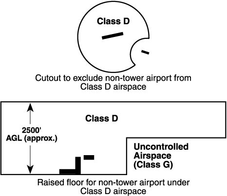
Figure 3-9. Class D, with cutouts or extensions.
Look at Hoskins Airport (44T), just east of Olympia (airport F on the chart excerpt) inside its Class D airspace. A pilot taking off from or landing at Hoskins (44T) must communicate with Olympia Tower and advise the controller of their intentions. There are no examples of cutouts or shelves on the chart excerpt.
The existence of Class D airspace is dependent on an operating control tower. There are hundreds of control towers that operate part-time, and when the controller goes home, the Class D airspace requirements usually go, too—the airspace often becomes Class E airspace that extends all the way to the surface.
You have to look at the Chart Supplement to be absolutely sure which classification of airspace is left behind when the controller at a part-time tower goes home. Look at the towered airports on the sectional excerpt for the Tacoma Narrows tower (J). It is a part-time tower, and if you look just below the “E” you will find “See NOTAMS/Supplement for Class D/E (sfc) hrs.” Olympia and Paine Field are also part-time with similar notations. What “Supplement” are they referring to? The Chart Supplement, of course. When these airports shut down, their surface areas become Class E down to 700 feet above the surface. There are part-time tower-controlled airports that go from Class D to Class G (non-tower) when the tower closes, but there are none on this chart. There is no substitute for the Chart Supplement in making this determination.
Class E Airspace
This class of airspace has already been fairly well-defined; it exists above the floors defined by magenta dashed lines (the surface), the blue and magenta tints (700 or 1,200 agl), and the MSL figures in mountainous areas (or 14,500 feet MSL). It extends upward to the floor of the overlying airspace (either Class A, B, or C).
Victor airways, the blue lines connecting NAVAIDs (VORs), are intended to be flown on their centerlines as accurately as possible. To allow for instrument errors, the airspace is protected from obstacles/terrain for four nautical miles on either side of the centerline. Victor airways extend upward from 1,200 feet above ground level (except in mountainous areas, where the floor of Class E airspace is designated on sectionals with a chain-link blue line) up to but not including 18,000 feet above sea level, and they do not lose their identity when passing through Class B, C, D, or E airspace. Because of their frequent use by crewed aircraft, sUAS operations near navigation aids and along Victor airways should be conducted with extreme caution.
The FAA is establishing Tango airways, to be navigated using GPS. They are also blue lines, but the airway identifier is T, as in T-139. They provide an easy way to circumnavigate congested and special use airspace without giving up the accuracy of GPS. T-routes are designated for low-altitude airspace (below 18,000 feet MSL).
Look at the airport data block for Paine Field (B), Tacoma Narrows (J), or Olympia (F). See the asterisk next to the tower frequency? That means that these are part-time towers, and you can find the actual operating hours on the back of the sectional chart or in the Chart Supplement. When the tower is not in operation, the airspace reverts to Class E and thus the communication requirement goes away.
Look at the Bremerton National Airport (D) at the left edge of the chart excerpt or Wenatchee (H) airport at the right edge. The magenta dashed line indicates that Class E airspace extends from the floor of the overlying controlled airspace down to the surface. At Bremerton, the overlying airspace begins at either 18,000 msl or 6,000 feet msl if within the Seattle Class B airspace boundary. At Wenatchee (Pangborn Memorial), Class E airspace starts at the surface within the dashed, magenta line, and begins at 700 feet AGL within the magenta rectangle. In both areas, the top of Class E airspace is 18,000 feet MSL (Class A airspace).
Now look at the Ellensburg airport (I) at the lower right edge of the excerpt. There is no dashed line, but Ellensburg does have an instrument approach, although you can’t tell that from the chart. An inbound instrument pilot’s protection stops at 700 feet AGL at Ellensburg; below that altitude the pilot is in Class G (uncontrolled) airspace and must mix in with the other types of air traffic.
Class G Airspace
An easy definition of Class G airspace is that it exists wherever other classes do not. Most of the Class G airspace lies beneath floors at 700 or 1,200 feet above the ground. Important note: Occasionally, the FAA establishes temporary control towers in Class G airspace for special functions such as fly-ins, Super Bowls, etc. As you might imagine, these towers do not show up on sectional charts (but they are announced by NOTAMs). Treat a temporary tower just as you would any operating control tower—mentally draw a five SM circle around the airport and get permission from the tower before entering its airspace.
Remember, it is paramount that commercial remote pilots recognize that they need ATC permission to fly in Class B, C, D, and surface-based Class E airspace per Part 107. In general, ATC will deny these requests “on the spot.” Instead, remote pilots should request access to such airspace using the airspace waiver form available from www.faa.gov/uas/commercial_operators/part_107_waivers.
Terminal Radar Service Area
A type of airspace that is rapidly disappearing is the Terminal Radar Service Area (TRSA, Figure 3-10). Indicated on charts by a solid black circle, a TRSA is a kind of voluntary Class C airspace. The only regulatory requirement for authorization for sUAS operations would be prior to entering Class D around the airport(s) centered within the TRSA.
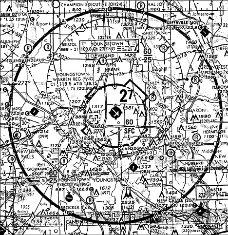
Figure 3-10. Terminal Radar Service Area.
Special Use Airspace
There are several types of special use airspace, but they are almost all indicated on charts with blue hatching. Look just to the right of the Olympia airport at the lower left corner of the chart excerpt.
The most restrictive is a Prohibited Area, such as that above the White House (Figure 3-11 is an example). Permission is required to enter a prohibited area and there is no way to get permission to fly a sUAS in a Prohibited Area. Getting caught in one is painful for both your pocketbook and remote pilot certificate.
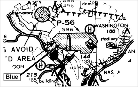
Figure 3-11. Prohibited Area.
Restricted Areas. The next step down is a Restricted Area (Figure 3-12). They are designated and controlled by the military and usually involve firing ranges, etc. A table on each sectional chart gives the operating hours and altitudes for each Restricted Area. The operating hours are not engraved in stone, however. During your preflight briefing, ask the FSS if a Restricted Area in the areas in which you plan to operate are “hot,” or give the controlling agency a call (at Navy Whidbey, the status of their Restricted Area is on the ATIS). According to regulations, remote PICs must get permission to fly within restricted airspace. But don’t expect to receive permission to fly in them unless you are part of what is going on inside of them.
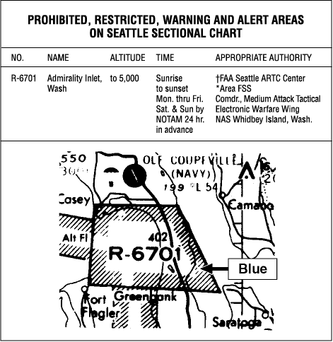
Figure 3-12. Restricted Area.
Temporary Flight Restrictions. Because of the increased emphasis on security at places where large groups of people (or government bigwigs) are congregated, the FAA is issuing NOTAMs implementing Temporary Flight Restrictions (TFRs) over sporting events, political gatherings, etc. Their dimensions and locations are included in the NOTAM. It is incumbent on every pilot to make a last-minute check for such restrictions before taking off. Regulations specifically state that remote PICs are just as responsible as crewed aircraft pilots to check for—and abide by—NOTAMs and TFRs.
Check for TFRs during flight planning by going to 1800wxbrief.com and selecting “FAA TFRs” under the Links tab; logging in is not required. Check again with FSS on the phone to be sure that nothing new has come up.
National Security Areas. The FAA has converted some TFRs to National Security Areas (NSAs), which are permanent but voluntary (pilots should avoid flying through NSAs, though). When it is deemed necessary, an NSA can be changed to prohibited airspace by NOTAM.
Warning Areas and Alert Areas (Figures 3-13 and 3-14). These areas also involve the military. Warning Areas have the same kinds of hazards as Restricted Areas but are offshore in international waters. No specific permission is required, but keep your eyes open. Check their status with FSS. Alert Areas involve a high volume of training activity. Again, no clearance is required, but extreme vigilance (or avoidance) is. Altitude and hours of operation for alert areas are typically provided along the fringes of sectional charts.
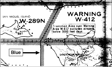
Figure 3-13. Warning Area.
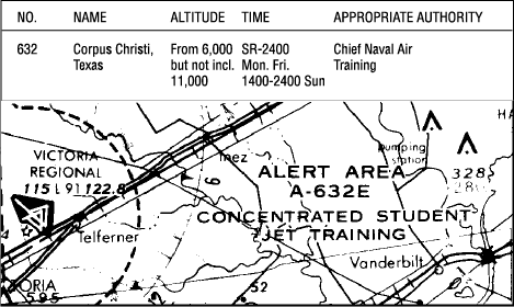
Figure 3-14. Alert Area.
Military Operations Areas (MOAs, Figure 3-15) are shown on charts with magenta hatching; again, look at the areas surrounding R-6703A, B, C, and D east of Olympia (that’s the Army’s Fort Lewis firing range, if you are curious). The altitude and hours of MOA operations are often included on sectional charts either adjacent to the airspace or along the edges of the chart. Always confirm times of operation with FSS or ATC. You do not need permission to fly in a MOA, but military airplanes operate in them without restriction—the regulations do not apply to them while flying in a MOA. Military pilots are not only flying at high speed, but they are not spending much time looking for hard-to-see sUAS. Your FSS can tell you the status of a MOA, of course, but the ATC Center (ARTCC) in whose airspace the MOA exists will be in direct contact with the military flights and can advise them of your presence. Your preflight planning should include getting Center frequencies from the Chart Supplement. Extreme caution should be exercised when operating near MOAs.
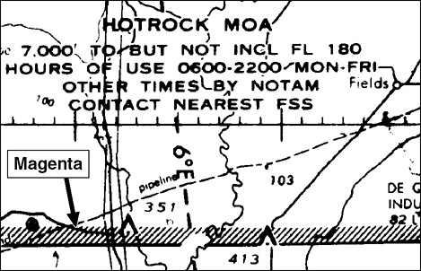
Figure 3-15. Military Operations Area.
Military Training Routes (MTRs) create a potential hazard for sUAS operators. The good news is that they are charted: see the gray lines that run from the top to the bottom of the chart excerpt west of Ellensburg? IR and VR mean instrument and visual routes, respectively, but there is more to it than that. Routes with 4-digit numbers are flown at or below 1,500 feet AGL, while routes with 3-number identifiers are flown above 1,500 feet AGL. Obviously, the 4-digit MTRs are the ones that most concern remote PICs. You can literally have fighter jets overhead at altitudes so low that you will feel the breeze from their displaced air as they pass by—definitely not good places to fly your sUAS.
“Hot” times for MTRs are available from the FSS, and you are foolish if you do not check on the status of any MTR that will cross your flight mission area. The military might schedule a route for several hours and only use it for a portion of that time, but you cannot afford to gamble. Military jet pilots fly very fast, with their heads in their cockpits, and they are painted with camouflage colors for a reason. Take note that the military is allowed to fly several miles off the centerline, so use caution when operating anywhere near an MTR.
Air Defense Identification Zones
Air Defense Identification Zones exist along the Pacific, Gulf, and Atlantic coasts, and aircraft inbound to the United States from outside of the ADIZ whose place and time of arrival within the zone are unknown will be intercepted by armed military aircraft. Although the regulations do not stipulate the requirements for sUAS operations in or near ADIZ, it is wise to avoid these areas or seek notification of ATC facilities that handle aircraft in the applicable area. This discussion does not include the ADIZ that surrounds Washington, D.C. Special restrictions apply in that area. The FAA A currently prohibits the flight of UAS within the District of Columbia and within a 30 NM radius of the Reagan Washington National Airport (DCA).
Wildlife Refuge Area
Along the bottom edge of the sectional chart excerpt, you will see Mount Rainier National Park. Note the line of dots that marks the boundary. Wherever you see those dots, they indicate a wildlife refuge area, and within this area you are asked, but not required, to stay at least 2,000 feet above the terrain to minimize the effect of aircraft noise on wildlife. Harassing, intentionally or not, certain types of wildlife can bring about penalties (monetary and/or prison). Remember that UAS are not permitted to fly in National Parks. Additional restrictions may exist for local and regional parks and similar land-use areas.
UAS Facility Maps
UAS pilots will also want to reference UAS Facility Maps (UASFM). These informational maps assist Part 107 pilots when determining approved locations and altitudes to consider when applying for airspace waivers.
The UASFM grid parameters are 1 minute of latitude by 1 minute of longitude; in most of the contiguous 48 states, this equates to one square mile or approximately 600 acres in all locations except in Alaska. UASFMs are only meant to suggest altitudes operators may want to consider when submitting their airspace authorization requests; they do not create any new types of airspace or grant approval.
The Department of Defense (DoD) facilities have been briefed on the mapping process, and the FAA currently manually processes requests into controlled airspace delegated to DoD facilities. The altitudes determined on UASFMs were determined by local airport facility Air Traffic Controllers, staff, and managers. If a request for an operation includes an altitude above what is displayed on the UASFM, it may still be approved but would need coordination with the facility and additional FAA safety analysis.
Recreational UAS operators who want to fly near airports must obtain an airspace authorization prior to operating in controlled airspace. Updates to the maps will coincide with the 56-day aeronautical chart production schedule, and changes to UASFMs will be released to the public in conjunction with the 56-day chart cycle.
The FAA may cancel an airspace authorization after it has been approved, and operators must comply with the operational rules of the country in which they are operating. ATC facilities will contact operators if there is an issue or problem.
Review Questions
For questions 1–30, refer to the Seattle sectional chart in Appendix D.
1. What are the latitude and longitude coordinates for the Easton State Airport (ESW) near letter “A” on the chart?
A—47° 15′ N 121° 11′ W
B—121° 11′ N 47° 15′ W
C—48° 45′ N 122° 49′ W
2. What is located at 47° 59′ N 120° 17′ W?
A—a sawmill
B—buildings
C—a mountain peak
3. What frequency should you use for announcing your sUAS operation in the vicinity of Snohomish (near letter G)?
A—123.00
B—120.20
C—122.90
4. What is the Common Traffic Advisory Frequency (CTAF) for the Kenmore Inc. Seaplane Base just northwest of Kirkland (south of letter B)?
A—14.00
B—100.00
C—122.70
5. There are two Kenmore Seaplane Bases near Lake Washington (between letters B and C). What is the difference between the two locations (why do they have different symbols)?
A—The north location has a control tower.
B—The north location has services such as fuel.
C—The south location has services such as fuel.
6. Which of the following is true about the Vashon (2S1) airport (between letters C and E)?
A—It is a private airport.
B—It has a runway that is 3,160 feet long.
C—It has soft surface runways.
7. What kind of lighting is available at the Cashmere-Dryden airport (47° 30′ 45″ N, 120° 29′ 15″ W)?
A—No runway lighting is available.
B—Rotating beacon only.
C—Pilot-controlled runway lighting (or on request).
8. How tall is the antenna about 8 miles south of the City of Wenatchee (near H)?
A—3327 feet
B—299 feet
C—2450 feet
9. Where would you look for information on how to contact an air traffic control center via a phone line?
A—Sectional chart legend
B—Aeronautical Information Manual
C—Chart Supplement
10. How much magnetic variation exists in the area around Ellensburg (I)?
A—47° 30′ North correction
B—15° 30′ West correction
C—15° 30′ East correction
11. You are flying in proximity to Port Ludlow (due west of B). What is the highest you can fly your sUAS while inspecting the tower just west of the city and south of DIGGN intersection?
A—400 feet MSL
B—400 feet AGL
C—605 feet AGL
12. You are approaching an airport within Class C airspace. Which of these statements is true?
A—You must have authorization from ATC before entering the Class C airspace.
B—You must be in two-way communication with ATC before entering the Class C airspace.
C—Your airplane must be equipped with a transponder, two-way radio, and GPS to enter Class C airspace.
13. Under what conditions, if any, may remote pilots enter a restricted area?
A—With the controlling agency’s authorization.
B—Following an ATC clearance.
C—Under no condition.
14. You have been asked to take photographs of the state capitol in Olympia, Washington (north of F). What type of airspace would you be in while flying around the building at 200 feet AGL?
A—Class E
B—Class D
C—Class G
15. What is the upper limit of Class D airspace?
A—18,500 feet MSL.
B—The base of Class A airspace.
C—Usually 2,500 feet above the surface.
16. What are the horizontal limits of Class D airspace?
A—5 NM from the airport boundary.
B—As indicated with blue dashed lines.
C—As indicated with magenta dashed lines.
17. Class D airspace is automatically in effect when
A—its associated control tower is in operation.
B—the weather is below VFR minimums.
C—radar service is available.
18. At what altitude does Class E airspace begin overhead Swanson airport (2W3) near Eatonville (between F and Mt. Rainier)?
A—400 feet AGL
B—700 feet AGL
C—1,200 feet AGL
19. Unless otherwise specified, federal airways extend from
A—1,200 feet above the surface upward to 14,500 feet MSL and are 16 NM wide.
B—1,200 feet above the surface upward to 18,000 feet MSL and are 8 NM wide.
C—the surface upward to 18,000 feet MSL and are 4 NM wide.
20. What type of airspace is associated with VOR federal airways?
A—Class B, C, D, or E airspace.
B—Class E airspace.
C—Class D airspace.
21. Class E airspace in the conterminous United States extends to, but not including,
A—the base of Class B airspace.
B—3,000 feet MSL.
C—18,000 feet MSL.
22. You have been asked to photograph the outdoor theaters in the vicinity of Bremerton National Airport (PWT) (near D). What type of airspace would you be within and what type of permission, if any, would be required?
A—Class E, ATC authorization required.
B—Class E, ATC authorization not required.
C—Class D, ATC authorization required.
23. At what altitude does Class E airspace begin over Kachess Lake (near A)?
A—14,500 feet AGL
B—700 feet AGL
C—1,200 feet AGL
24. You are planning a mission to map a plot of land near Rosedale (northwest of J). Prior to launch, you listen to the Tacoma Narrows ATIS, which is reporting 2 SM visibility in mist. Can you fly the mission?
A—Yes, if you have at least 3 SM ground visibility at your location.
B—Yes, if you have at least 3 SM of flight visibility at your location.
C—Yes, as visibility restrictions only apply if flying within Class D airspace.
25. You have been asked to inspect towers north of Bangor, which is north of area D. Which of the following is true about this mission?
A—You can fly your sUAS up to 885 feet AGL.
B—All towers at that location have anti-collision lights.
C—The mission is not authorized.
26. Are you authorized to operate your sUAS over Yelm (East of F near Western airport)?
A—No, you are in restricted airspace.
B—No, you are in a Military Operations Area (MOA).
C—Yes, there are no restrictions to operations.
27. What is the significance of the different colors of airports (for example, Snohomish County, near B, and Harvey, near G, are different colors)?
A—Blue airports have a control tower.
B—Magenta airports have a control tower.
C—Blue airports always have surface-based Class E airspace.
28. Renton airport (RNT) (northeast of C) is surrounded by Class D airspace up to and including
A—2,500 feet MSL.
B—2,500 feet AGL.
C—3,000 feet MSL.
29. Would you expect to see aircraft flying in the traffic pattern north of Firstair airport (W16) (east of G)?
A—No; the patterns for both runways are to the south of the airport.
B—Yes; the traffic patterns for each runway are opposite of one another.
C—Yes; the traffic pattern for runway 7 is to the right.
30. Which of the following hazards to flight exists north of the Sky Harbor airport (S86) (east of G)?
A—A major road
B—A railroad
C—Powerlines
For questions 31–34, refer to the Chart Supplement excerpts in Appendix C.
31. When is the Olympia Regional Airport (OLM) control tower in operation in local time?
A—0800–2000 (0900–2100 during daylight savings)
B—0800–2000 all year
C—1600–0400 all year
32. Which is not a suitable means for receiving the weather conditions at Ellensburg Bowers Field airport (ELN)?
A—Call 509-962-7523.
B—Call 509-925-2040.
C—Listen on frequency 118.375.
33. What type of airspace exists at the Olympia Regional Airport (OLM) when the tower is closed?
A—Surface-based Class D
B—Surface-based Class E
C—Surface-based Class G
34. Where is the control tower located on the Olympic Regional Airport (OLM)?
A—West of runway 35-17 and south of a ramp area.
B—On the far west end of the airport under the star symbol.
C—Just east of runway 35-17 indicated by the triangle shape.
For questions 35–40, refer to the North Alabama sectional chart excerpt in Appendix D.
35. You are planning to operate your sUAS just west of the Talladega airport (ASN). What factors may you want to consider before flying?
A—You need ATC authorization to fly in the vicinity of ASN.
B—You should avoid flight in the area due to national security.
C—You should check NOTAMs for sporting events.
36. What type of airspace exists at the surface on and around the Anniston Regional Airport (ANB)?
A—Class C
B—Class D
C—Class E
37. What type of airspace exists at the surface on and around the Birmingham Shuttlesworth International Airport (BHM)?
A—Class C
B—Class D
C—Class B
38. For a flight at 200 feet AGL over Trussville (just northeast of the BHM airport), what kind of ATC authorization is required?
A—No ATC authorization is required; Class G extends to 1,200 feet AGL.
B—ATC authorization is required; the area is within Class C airspace.
C—ATC authorization is required; the area is within Class E airspace.
39. The multiple (two or more) towers just north-northwest of and closest to the Anniston Regional Airport have tops that are _____ feet above the airport elevation.
A—215
B—1,305
C—403
40. What frequency should you use for announcing flight activity in the vicinity of St. Clair County Airport (PLR)?
A—119.625
B—123.05
C—123.80
41. If a UAS Facility Map includes the area where I want to operate a UAS, does that mean I can fly without any authorization?
A—No, the maps are for informational purposes only.
B—Yes, as long as the pilot contacts Air Traffic Control.
C—No, these maps are only authorized government agencies authorization to fly at the designated altitudes.
Answers:
1-A, 2-B, 3-A, 4-C, 5-B, 6-C, 7-C, 8-B, 9-C, 10-C, 11-C, 12-A, 13-A, 14-B, 15-C, 16-B, 17-A, 18-B, 19-B, 20-A, 21-C, 22-A, 23-C, 24-B, 25-B, 26-C, 27-A, 28-A, 29-A, 30-C, 31-B, 32-A, 33-B, 34-A, 35-C, 36-C, 37-A, 38-C, 39-B, 40-B, 41–A.
1. Airports in Hawaii and Alaska use the prefix “P,” while Puerto Rico uses “T.”
2. A NAVAID is a radio navigation facility that provides guidance to crewed aircraft and that is used to define routes of flight. If flying from Columbus, Georgia, to Montgomery, Alabama, the route could be stated as KCSG-CSG-V20-MGM-KMGM (Columbus airport to Columbus NAVAID via Victor Airway 20 to Montgomery NAVAID to Montgomery airport).