
Uncrewed Aircraft Systems: Learning the Language of Drones
A Very Brief History of Uncrewed Aircraft Systems (UAS)
Here is a question to get us started: when was the first drone (which we will refer to as UAS) flown? What’s your guess? Would you believe that it was in August of 1849? While the Austrians were laying siege to the city of Venice, Italy, they concocted a plan to send balloons with attached explosives to bombard the city. While one could argue that these were not UAS as we imagine them, they constituted one of the first uses of an aerial system to complete a mission of sorts. Similar tactics were employed during the American Civil War but were not entirely effective. In 1896, Samuel Langley launched an uncrewed aircraft, the Aerodrome, from a catapult housed on his floating barge. It wasn’t until World War I between 1916 and 1917 that the first guided, pilotless winged aircraft were flown—some to serve as targets and others to deliver bombs, the latter which were referred to as aerial torpedoes, guided by rudimentary autopilots.
World War II brought forth a slew of UAS from both Axis and Allied forces. Germany’s V-1 “buzz bomb” had a simplistic guidance system that would cut the engine when assumed to be in the target area. The United States also experimented with remote control technologies to convert existing crewed aircraft into UAS. One example was Project Aphrodite, in which B-17 bombers were made into flying bombs. Pilots were on board to take off and to arm the warhead. After remote control was engaged, the pilots would parachute out. Probably the most prolific use of UAS during this period was as targets, with more than 12,000 target drones used to assist aerial gunners and pilots practice their shooting skills.
Most of the UAS activity from World War II to Vietnam continued to be in the form of target flights or flying bombs. Eventually, the latter evolved into the modern-day cruise missile. UAS were later used for reconnaissance, typically launched from an airborne platform such as a Lockheed C-130 Hercules. Following the Vietnam War, the United States dramatically slowed its drone research and production, but other countries, notably Israel, made leaps and bounds, paving the way for the UAS age as we know it.
Around 1990, the United States became increasingly interested in using UAS to perform missions that would typically be too boring or dangerous for crewed aircraft pilots. Thanks to the Global Positioning System (GPS) and advances in sensors, computational power, and other components, UAS could be accurately guided to precise target locations and perform a range of missions from reconnaissance to attack. By 1994, companies were producing uncrewed war machines. UAS such as the now-familiar Predator and Global Hawk came to fruition. Since 2000, the US military has rapidly increased its use of UAS to perform tactical missions across the globe. Today, headlines frequently highlight the US military’s use of UAS. However, these types of UAS are not commonly seen within the borders of the United States (although they do fly here—for training, special missions, and border protection purposes), and they do not resemble the types of systems most remote pilots will operate.
While militaries were figuring out how to utilize UAS for war, radio-controlled aircraft as we know them today were concurrently being developed. In fact, the technologies went hand in hand. The ability to control an object via radio came about in 1898, thanks to Nikola Tesla. A more sophisticated control system was tested in 1903, using radio waves to execute specific commands on a robot. By 1917, such technologies were being used in UAS. Throughout the period of the World Wars, remote control aircraft became more sophisticated and popular. In the 1950s, gas- and battery-powered, remote control aircraft truly sparked the hobby flying market. By 1968, there were even remote-controlled helicopters. As batteries have improved, computers and other components have shrunk, and as prices of these items have become more reasonable, the world of remote control flying has become more accessible to a wider audience. While much of the remote-controlled flying done before the early 2000s was for recreation or as a hobby, it quickly became apparent that UAS has much more capability and potential. Fast-forward to today, and UAS use has grown dramatically. As of December 2024, the FAA shows over one million drones registered in the US, and the actual number of drones flying is likely to be much higher. As of 2025, more than 444,950 aviators held Remote Pilot Certificates, and more than one million people had completed the recreational use test known as TRUST (the Recreational UAS Safety Test).
Today’s drones are technologically advanced tools that can be used to perform a very wide range of functions, from simple photography to assisting farmers through the use of precision agricultural sensors to package delivery. Your imagination is the only limit to what modern UAS can do. Of course, a UAS is only as good as its pilot, so let’s start digging into the details on how to become one.
Terms and Abbreviations
Both the crewed and uncrewed aircraft worlds have their own set of terms and abbreviations. Wouldn’t you be a little nervous if you asked a doctor, “Hey doc, what are the results of my thoracic CT scan?” and they looked at you puzzled, responding “A what kind of scan? What is a CT?” Similarly, you want to be able to use and understand the UAS/aviation talk. Terminology is essential to being a knowledgeable remote pilot, but it can also be a critical part of communication with other UAS operators and personnel as well as conversations you may need to have with pilots and air traffic controllers.
Below are some of the most common UAS and aviation-related terms and abbreviations that are important for you to know.
AC Advisory Circular—an advisory document released by the FAA to provide additional guidance on important subjects that goes beyond the explanations in the regulations and other documents.
AGL Above ground level—the height, in feet, of an object (e.g., tower or UAS) above the underlying local area terrain.
AIM Aeronautical Information Manual—An FAA publication applicable to all types of aviation/aerospace operations. Provides detailed information on topics such as air traffic control, weather, airports, and other subjects critical to remote pilots.
AIRMET Airman’s Meteorological Information—a current and forecast weather warning covering a specific area that is applicable to small aircraft and UAS (e.g., for windy conditions, turbulence, low visibilities).
AOA Angle of attack—the angle between the middle of an airfoil (i.e., wing or rotor blade), referred to as the chord line, and the relative wind. Relative wind is air moving opposite the direction the aircraft/wing/rotor is moving.
ATC Air traffic control—a service provided by ground-based personnel in charge of separating aircraft in controlled airspace. Remote pilots may have to contact ATC in specific situations.
ATCT Air traffic control tower—a facility responsible for handling departures, arrivals, and ground operations at an airport (or airports).
ATIS Automatic Terminal Information Service—a continuous broadcast of non-control aeronautical information. Provides weather information for the transmitting airport.
BVLOS Beyond visual line of sight—anytime a drone is operated out of view of the remote PIC and visual observer. Special authorization is required for BVLOS operations.
CBO Community-based organizations—are FAA-recognized groups that meet the statutory requirements outlined in Section 44809(h) of the Exception for Limited Recreational Operations of Unmanned Aircraft. These organizations, which must be 501(c)(3) tax-exempt entities with a mission to advance model aviation, provide comprehensive safety guidelines, support local clubs, and assist in developing model aircraft flying sites. Recreational drone flyers must follow FAA-recognized CBO safety guidelines to comply with Section 44809(a)(2), but membership in a CBO is not required. Recognized CBOs, such as the Academy of Model Aeronautics, First Person View Freedom Coalition, Flite Test Community Association, and STEM+C Inc., can apply for fixed flying sites, sponsor events, and establish FAA Recognized Identification Areas (FRIAs).
CFI Certificated Flight Instructor—an individual who is licensed to provide flight and ground instruction.
CFR Code of Federal Regulations—the codification of the general and permanent rules and regulations published in the Federal Register. Title 14 of the CFR applies to areas of operation and certification of UAS and other aviation/aerospace vehicles.
COA Certificate of Waiver or Authorization—a special waiver or authorization by the FAA to allow operations beyond those defined by Part 107. Operators with COAs are allowed to continue to operate under them until they expire.
CT Control tower—see ATCT.
DPE Designated Pilot Examiner—a person designated by the FAA to represent the administration in the issuance of pilot certificates and to conduct practical exams.
FAA Federal Aviation Administration—the government entity charged with regulation, enforcement, and promotion of the aviation/aerospace industry in the United States. Also charged with ensuring safe operations in the NAS.
FPV First-person view—the ability of a remote pilot to utilize a camera onboard a UAS to see from the perspective of the UAS in flight. The view is displayed on a screen that is part of the controller, on a tablet/smartphone, and/or in FPV goggles worn by the remote pilot.
FRIA FAA-Recognized Identification Area—the only locations uncrewed aircraft (drones and radio-controlled airplanes) may operate without broadcasting remote ID message elements. Usually sponsored by community-based organizations or schools.
FSO Flight Standards office—the responsible local field office serving as a representative of the FAA, providing services and handling compliance relating to aviation/aerospace for a specific geographic area.
FSS Flight Service Station—the provider of flight and weather services to pilots. FSS can be accessed via the Internet or phone.
GCS Ground control station—the ground-based means of controlling a UAS. Also known as the controller.
GPS Global Positioning System—a US-based network of satellites that provides very accurate position information to aircraft and some UAS. GPS is one of several Global Navigation Satellite Systems (GNSS). For example, Russia has its own system called GLONASS.
IFR Instrument flight rules—the set of FAA rules that applies to aircraft flying on IFR flight plans and that allows aircraft to fly in poor weather (less than 3 SM visibility and cloud heights below 1,000 AGL; referred to as instrument meteorological conditions, or IMC). IFR aircraft primarily navigate with sophisticated instruments and navigation systems, such as GPS.
LAANC Low Altitude Authorization and Notification Capability—a collaboration between the FAA and private sector to provide UAS operators a means of requesting authorization to operate in airspace that otherwise would exclude such operations.
METAR Aviation Routine Weather Report—a weather report, usually distributed each hour, from airports with weather observation capabilities.
MOA Military Operations Area— a type of special use airspace, designed to separate military aircraft training and activities occurring in the designated area from non-military air traffic. sUAS typically should avoid operating in MOAs.
NAS National Airspace System—the various types of airspace as well as the airports, ATC facilities, technology, and related rules and regulations that exist in the United States.
NM Nautical mile—a distance of 6,076 feet or approximately 1.15 statute miles. NMs are used for most aviation navigation distance measurements.
NOTAM Notice to Airmen—a notification of a change to expected or documented procedures or operations. Examples may include if a control tower frequency has changed or airspace is restricted due to the President being in the area. Be sure to check for NOTAMs before each flight to avoid unwanted attention from the FAA or law enforcement.
NTSB National Transportation Safety Board—the government agency in charge of investigating transportation accidents in the United States.
PIC Pilot-in-command—the person in charge of the operation of an aircraft. In the case of UAS, they are referred to as the remote PIC. Note that the remote PIC does not necessarily have to be at the controls of the UAS.
RID Remote identification—the ability of a drone in flight to provide identification and location information that can be received by other parties.
RPAS Remotely piloted aircraft system—the term used by many countries outside the United States to describe UA or UAS. RPAS is generally synonymous with UAS.
RPIC Remote pilot-in-command—the person in charge of the operation of a UAS. Note that the remote PIC does not necessarily have to be at the controls of the UAS.
RWY Runway—pavement used by crewed aircraft for takeoff and landing.
sUAS Small uncrewed aircraft system—a UAS that weighs less than 55 pounds (25 kg).
SIGMET Significant Meteorological Information—a weather warning covering a specific area and that is applicable to all types of aircraft and UAS (e.g., for extreme and dangerous conditions).
SM Statute mile—a distance of 5,280 feet. Commonly referred to as miles in non-aviation contexts. SM are sometimes used for distances in aviation, such as in aviation weather reports (METARs and TAFs).
TAF Terminal Area Forecast—an aviation weather forecast for a specific airport.
TFR Temporary Flight Restriction—a restriction to flight operations issued via NOTAM. Flight into a TFR can have dramatic consequences usually involving law enforcement or government agencies. Be careful to avoid these.
TSA Transportation Security Administration—the government entity charged with the safety of transportation in the United States. The TSA will vet potential remote pilots prior to the FAA issuing permanent certificates.
TWY Taxiway—pavement used by crewed aircraft to taxi to and from runways.
UA Uncrewed aircraft—term used to describe the actual aircraft that is part of a UAS (i.e., excludes the ground station/controller).
UAS Uncrewed aircraft system—the total system associated with an uncrewed aircraft, including the ground station/controller, sensors, processors, and other components. UAS is also used generically to refer to a drone or remote-controlled aircraft. Previously referred to as unmanned aerial vehicles (UAV).
UTC Universal Time Coordinated—a standard time used in aviation operations based upon the time in Greenwich, United Kingdom, uncorrected for daylight saving time. Given in 24-hour (military) format. Also referred to as Zulu time. UTC is used in communications, NOTAMs, and weather forecasts.
VFR Visual flight rules—the set of FAA regulations that dictate operations by aircraft not flying under IFR. VFR flight requires good weather conditions (i.e., more than 3 SM visibility and cloud ceiling heights above 1,000 feet). VFR aircraft navigate with the assistance of visual cues.
VLOS Visual line-of-sight—the ability of the remote pilot to see the UAS without any aids to vision (such as using FPV or binoculars).
VOR Very High Frequency Omnidirectional Range—a navigational aid used by aircraft, often to define aircraft routes or position.
WX Weather—a common abbreviation used when referring to aviation weather conditions.
Types of UAS
Just as there is a cornucopia of crewed aircraft, UAS come in various sizes, shapes, and configurations. With few exceptions, at least in the near-term, most civilian UAS remote pilots will be operating small UAS (sUAS), which are defined as those weighing less than 55 pounds. This text will focus on sUAS operations, though most of the details outlined are also applicable to larger UAS.
UAS are divided into two primary categories: fixed-wing and rotor-wing. Fixed-wing UAS generate the lift necessary to fly from a wing, just like a conventional aircraft. Rotor-wing UAS generate the lift needed to go aloft through rotors (essentially propellers oriented horizontally to provide lift vertically), just like a helicopter. Rotor-wing UAS are classified by the number of rotors that they utilize for flight; for example, a UAS with a single rotor is considered a helicopter, while one with several rotors is referred to as a multicopter. A common configuration of four vertical propellers/rotors is referred to as a quadcopter. Figure 1-1 shows typical UAS configurations.
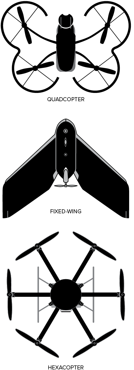
Figure 1-1. Typical UAS configurations. (Halftermeyer; commons.wikimedia.org/wiki/File:Parrot_fleet_of_Drones.jpg; CC BY-SA 4.0)
UAS use one of two types of engines to produce power to fly—internal combustion or electric. Internal combustion engines are typically used in larger UAS as well as in hobby/model aircraft, while electric seems to be the power source of choice for sUAS, particularly for multicopters. Obviously, internal combustion engines require some kind of fuel, a means to store it, and a way to induce combustion. Electric engines require a fuel of sorts, as well, in the form of batteries (or even solar panels). Because most of the various components needed for sophisticated sUAS use electricity, and conserving size as well as weight is important, batteries are the ideal choice for powering sUAS.
UAS Components
Just like crewed aircraft, UAS are comprised of numerous subsystems that allow for controlled flight as well as more utilitarian functions such as providing navigation and position information, speed and altitude measurements, and the ability to take pictures and videos. Figure 1-2 shows the “guts” of a typical quadcopter. While internal components of sUAS vary in regards to size and capability, in general the innards of UAS are very similar. For example, all UAS have flight controllers, systems to manipulate the engine(s), a power source (battery or fuel), and a means to communicate with the ground station/controller that the remote pilot uses to fly the UAS.
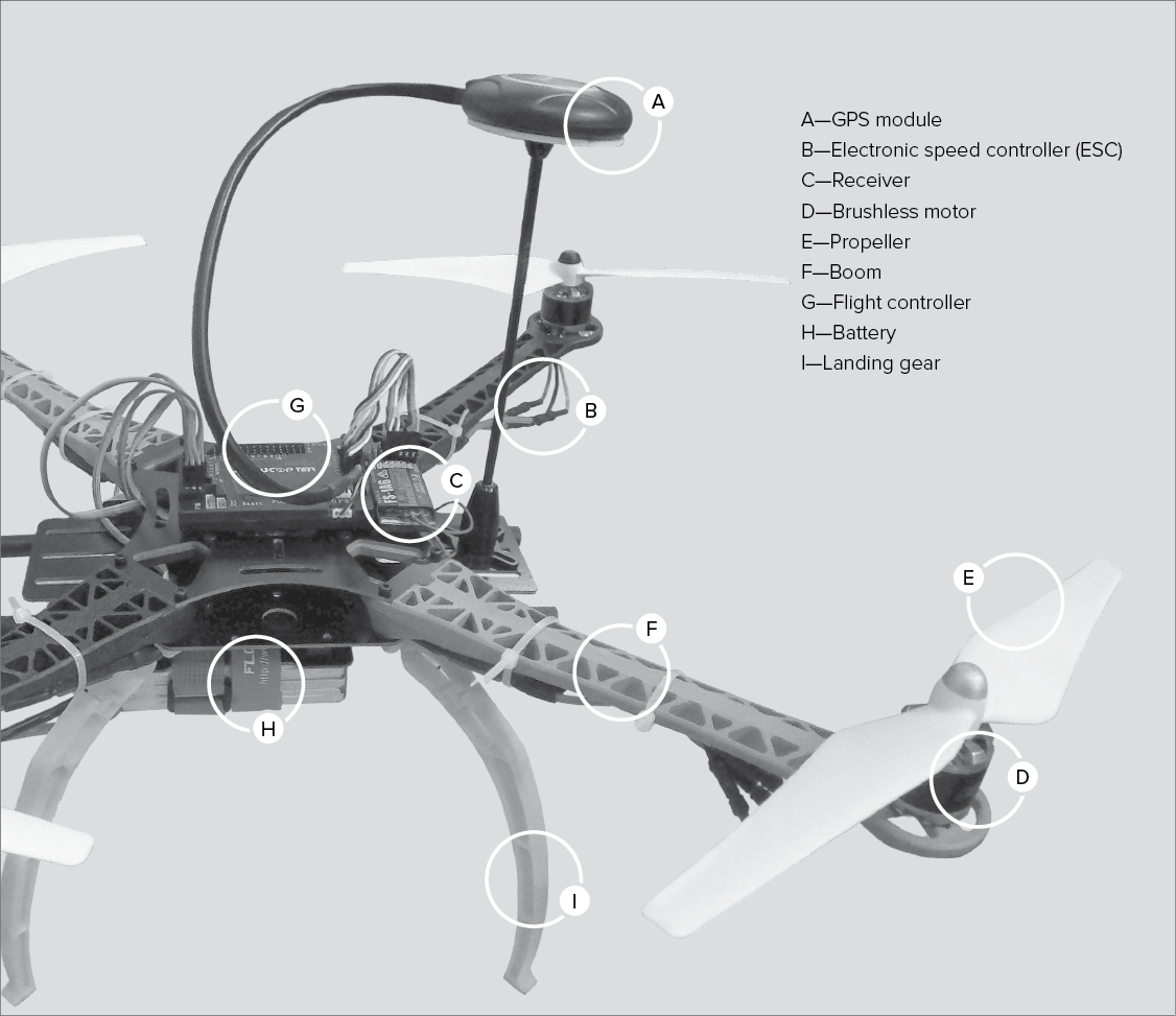
Figure 1-2. Typical quadcopter components.
Flight Controller
The brain of the UAS is the flight controller. This device interprets the inputs from sensors and the remote pilot’s controller commands. Onboard sensors often include GPS, an inertial measurement unit (IMU), an altimeter, and a magnetometer (i.e., a fancy compass). Additionally, some UAS have autopilots to allow for autonomous navigation, which can be programmed to fly preplanned routes, circle objects, or follow the remote pilot. The flight controller manipulates the speed of the motor(s) to execute the commands of the remote pilot or autopilot. It also is used to manipulate other sensors, such as the onboard camera. If installed, a GPS module can provide extremely accurate position information that can be used to superimpose the UAS position on a map (such as on a controller display or in FPV). GPS is available just about anywhere on Earth as long as the UAS has a clear “view” of the sky, thanks to the constellation of satellites that constantly transmit the data needed for the GPS module to determine its location. Obviously, GPS will not work indoors, so remote pilots should familiarize themselves with any limitations to UAS use when GPS is not available. Many UAS use GPS to stabilize their positions, making it very simple to fly and essentially allowing for “hands off” hovering. Some UAS can become less stable when GPS is unavailable. Another useful feature of GPS is that it allows a UAS to note the position where it launched and automatically return to this “home” location if commanded to do so or in abnormal situations (such as controller signal loss or getting too far from the controller transmitter). One caveat is that the Return to Home function of most UAS is not aware of trees or buildings that may exist between the UAS’s current position and the remote pilot. You do not need much imagination to understand how that could ruin your day. When beyond visual line-of-sight (BVLOS) operations are permitted, GPS can assist the remote pilot in flying the UAS long distances from the launch point and in tracking specific routes. For example, a UAS operation could include the UAS launching from a safe vantage point, flying over a dangerous chemical leak, loitering, taking pictures or video, maybe even using infrared or other sophisticated sensors, and flying home—all with little or no input from the remote pilot.
Communications Components
For the UAS to communicate with the ground station/controller, it must have an antenna and a receiver. The antenna may be obvious, appearing like a little pencil or whip extending from the top (or other part) of the UAS, or it can be integrated into the structure of the UAS. The receivers on most UAS are the types used on remote-controlled (RC) aircraft, with different numbers of channels based upon needs. (Channels are necessary to send different messages to components, such as motors and cameras.)
As of 2024, most UAS are required to have remote identification (Remote ID), a crucial aspect of the integration of drones into the National Airspace System (NAS). It allows drones to provide identification and location information through a broadcast signal, laying the groundwork for complex drone operations and helping the FAA, law enforcement, and other federal agencies locate control stations when a drone appears unsafe or not allowed to fly. Drones must comply with Remote ID rules, including those flown for recreation, business, or public safety. There are two ways to be Remote ID compliant: using a Standard Remote ID drone with built-in capabilities or using a drone with a Remote ID Broadcast Module attached. Drones without Remote ID can fly within a FAA-Recognized Identification Area (FRIA), a defined geographic area where drones can be flown if they don’t have Remote ID equipment. Recreational drone pilots can register once and apply their registration number to all devices listed within their inventory. Details on Remote ID can be found in 14 CFR Part 89.
Batteries
Both electric and internal combustion UAS utilize batteries. For UAS with electric engines, the battery is the primary source of power for the engine(s), flight controller, servos (if applicable; these move flight controls or other parts), autopilot, and sensors. Some UAS have a stand-alone camera with its own battery, while on others, the camera is powered by the primary onboard power source. On simple, internal-combustion UAS, fuel is used to power the engine, but batteries are still used to power servos and other onboard components.
Sophisticated, combustion-engine UAS may employ onboard electric power generation through a generator or alternator. UAS batteries must be lightweight and able to deliver enough power to operate the vehicle for a reasonable period of time; thus, they are generally high-capacity nickel-cadmium (NiCad) or lithium polymer (LiPo) types. LiPo batteries have gained popularity with sUAS because they are lighter, have larger capacities, and can deliver higher discharge rates. Unfortunately, LiPo batteries must be used with caution because if damaged or mishandled, they can explode or catch fire (see Chapter 10 for more details).
Batteries are marked with various numbers that provide details about their capabilities. A LiPo battery cell has a nominal voltage of 3.7 volts (V). To increase capacity, multiple cells are combined inside a battery, and this will be indicated on its cover. For example, a 2S battery indicates that two cells are installed in series (S) giving a total voltage of 7.4 V (3.7 V × 2). Electric motors are rated by kilovolts (kV), which translates to rotations per minute (RPM) per volt. More volts equals higher motor speeds. Battery capacity is measured in milliampere-hours (mAh), which can be thought of as the size of the “fuel tank.” Capacities vary depending on the manufacturer and UAS platform type. If a battery is marked with 5,000 mAh, this means that the battery can provide one amp (A) for an hour for every 1,000 mAh (after all, a milliamp is 1/1000 of an amp). Thus a 5,000 mAh battery can supply 1 A for five hours, 2 A for two and half hours (5,000 mAh ÷ 2 A = 2.5 hours; remember, 2 A = 2,000 mAh), 5 A for one hour, and so forth.
Another number you will see on batteries is the discharge capacity, denoted by the letter “C.” For example, 50C means that the discharge capability of the battery is 50 times the capacity in amps. Suppose we have a 5,000 mAh (i.e., 5 A) battery with a 50C discharge rating. In that case, it can sustain a maximum continuous output of 250 A (50 × 5 A = 250 A). Battery charge rate, also noted on the battery, is rated in terms of “C.” Utilizing the same aforementioned formula, if a 5,000 mAh battery has a 5C charge rating, it can safely be charged at 25 A (5 × 5 A capacity = 25 A).
A battery monitor is often installed on a UAS to track the status of the battery, providing feedback to the remote pilot. The current battery capability is typically displayed somewhere on the controller and/or causes the UAS to perform certain commands (e.g., return home) when the battery is low. As is evident from these descriptions, batteries are complicated components of UAS, and further discussion is beyond the scope of this book. It is wise for remote pilots to become familiar with the various attributes and capabilities of the batteries onboard their specific UAS.
Electronic Speed Controllers
Electronic speed controllers (ESCs) for each electric motor are connected to the flight controller. ESCs convert onboard direct current (DC) power to the alternating current (AC) used by UAS motors. They also control the motor speed and direction. Each ESC is connected to the motor it controls. Motors attach to the frame (fuselage) of the UAS via motor mounts. The latest technology uses brushless motors, which are quieter and more reliable than older motors that employed brushes.
Fixed-wing UAS have very simple motor arrangements, rotating propellers to either push air (when the propellers are mounted on the back of the UAS) or pull air (when mounted on the front). Multicopters have more complex setups with multiple motors spinning propellers in different directions to counteract torque. Considering Newton’s third law—for every action, there is an equal and opposite reaction—if all propellers rotated in the same direction, it would be problematic to control the UAS. Also, the propeller rotation is arranged so that some propellers push and others pull. In a quadcopter, the propellers in the “front” of the UAS pull (also referred to as tractor propellers) and the ones at the rear push. Multicopters with more motors become more intricate. Of course, a propeller that rotates in a clockwise direction cannot be the same as one that rotates counterclockwise. Essentially, the propeller blade angles are reversed so that thrust (lifting power) is appropriately generated. UAS manufacturers mark the propellers and motors to ensure they are properly matched. For fixed-wing UAS, control comes from the movement of flight controls similar to crewed aircraft. These are electrically actuated by servos linked to the flight controller/receiver.
Additional Component Options
UAS usually have some type of landing gear, which can be as simple as a skid or a pole, or more complex involving wheels or the ability to retract (or both). Additional features may include a camera or other sensors. Simple UAS have cameras fixed to the body of the aircraft, giving them minimal utility since the remote pilot must aim the aircraft appropriately to get the desired picture or video. Advanced UAS employ cameras that can be controlled by the operator via a gimbal motor and control unit, providing the ability to tilt the camera left and right, and perhaps up and down. The ideal installation includes a gimbal, which is a stabilization feature that helps dampen vibration effects and potentially keep the camera image level as the UAS maneuvers. Some cameras are integral parts of the UAS (i.e., provided by the manufacturer), while other UAS allow for the attachment of a user-provided camera or other sensor. For UAS flying at night, anticollision lighting must be installed that complies with the requirements of 14 CFR §107.29.
Controller
The controller serves as the interface between the remote pilot and the UAS. Figure 1-3 shows an example controller. While controller features vary, they commonly all have two primary control “sticks.” These sticks control the motor(s) and movement of the UAS. In the “standard” configuration (Mode 2), the left stick controls the motor (thrust) and the yaw (nose left/right) of the aircraft while the right stick controls the pitch (nose up/down) and bank/roll (wing and side angles left/right) of the aircraft (Figure 1-4).
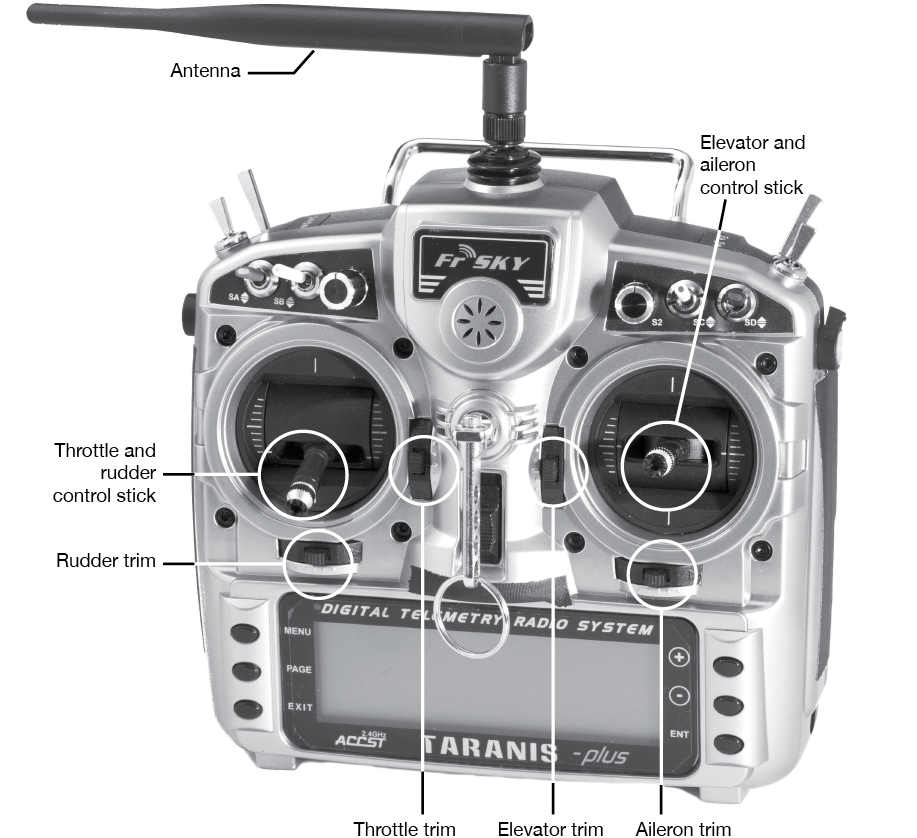
Figure 1-3. Controller. This configuration is the most commonly used setup. However, some controllers allow for customization of switches and stick functions. (Lucasbosch; commons.wikimedia.org/wiki/File:FrSky_X9D_Taranis_plus_2.4_GHz_handheld_RC_transmitter.jpg; CC BY-SA 3.0)
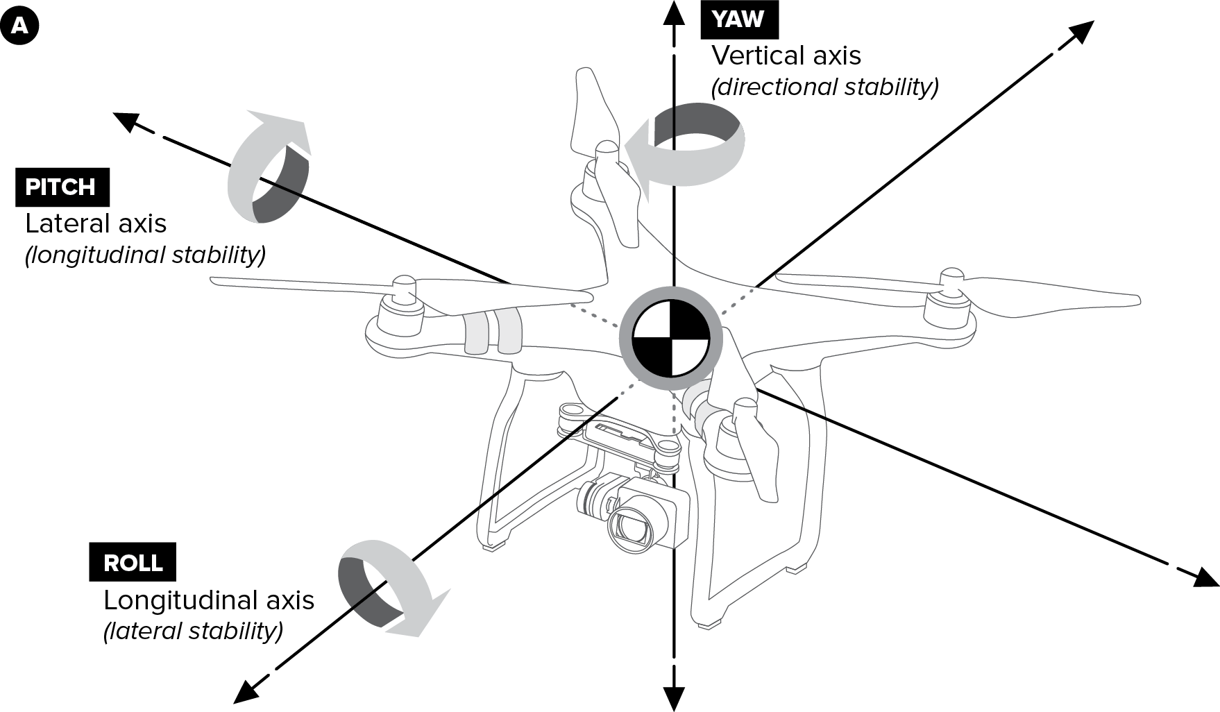
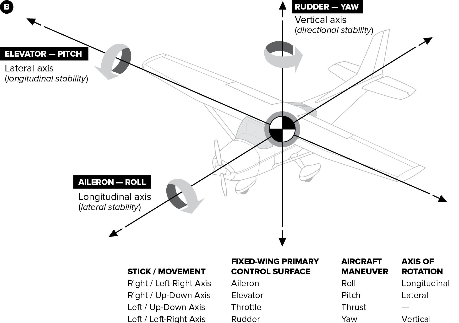
Figure 1-4. Control inputs and axes for (A) multicopter and (B) fixed-wing UAS.
With the left stick, pushing it forward (up) increases motor speed, and pulling it back decreases motor speed; pushing the stick to the left yaws the aircraft left, and pushing it right yaws the UAS to the right.
When manipulating the right stick, pushing forward will cause the UAS to move forward (multicopter) or nose down (fixed-wing), and the opposite occurs when the stick is pushed backward. Pushing the right stick left or right will cause the aircraft to move or bank in the same direction as the stick is pushed.
Individual controllers may include various other extra buttons and controls. On some models, there is a switch to change between control modes, which typically include a more stable mode or modes for beginners and a less stable mode or modes for those with more operating experience. A common feature is a “headless” mode, which allows the user to control the aircraft without having to consider which way it is “facing” (i.e., the joystick on the controller will direct the UAS to the right, left, forward, or backward from the user’s perspective, regardless of the UAS’s orientation). This may be helpful because without headless mode, when the aircraft is flying towards the remote pilot, the left/right control inputs need to be reversed, because a stick input for a right bank/movement will cause the aircraft to move towards the remote pilot’s left (since the aircraft’s right is to the user’s left).
Additional control features may allow for flying with or without GPS inputs (if installed), although flying with GPS inputs typically provides much more stability and the capability to fly hands off the controls. Additional switches or controls may be available to control the gimbal/camera, if installed. Some controllers have status screens or even first-person view displays. It is also typical to have control “trim,” which allows for fine adjustments to the yaw and turning controls in case the aircraft drifts when the remote pilot releases the controls.
Some UAS manufacturers provide their own customized controllers. These are typically simplified versions of commercially available RC aircraft–type controllers. Also, many manufacturers leverage cellphones or tablets as screens to monitor the UAS flight and to view the onboard camera imagery.
Common Uses of sUAS
Flying sUAS can certainly be a fun hobby. The advent of first-person view (FPV) technology allows the user to be fully immersed in the aircraft. Also, sUAS provide a means to take photographs and videos from perspectives not previously possible without spending lots of money or becoming a crewed aircraft pilot. Even drone racing has caught on to the point that it is receiving sponsors and television coverage. In addition to the many fun things you can do with sUAS, these devices have many practical applications, as well:
- Real estate agents are using sUAS to survey and photograph the properties they are selling.
- Farmers are using these systems for precision agriculture, allowing them to see which crops need more water or fertilizer and even which crops are being weakened by pests.
- Search and rescue personnel use sUAS to find lost hikers and missing animals.
- Game wardens employ sUAS to protect endangered species and track down poachers across the globe.
- Scientists use these systems to monitor the environment, study animal life, and collect other types of data.
- Companies deploy sUAS to inspect and monitor their assets such as powerlines, plants, and transmission towers.
- Security and law enforcement personnel utilize both fixed-wing and multicopter sUAS to provide surveillance and monitoring to protect the public or specific assets.
- News crews are adopting sUAS to assist in aerial coverage and to provide unique aerial perspectives.
- Film makers also utilize sUAS for aerial views, providing amazing footage that otherwise would have been impossible or would have required elaborate equipment or crewed aircraft.
- Firefighters use sUAS to monitor fires, track fire suppression processes, and even extinguish fires.
- Delivery of time-sensitive and consumer goods is increasingly being conducted with sUAS.
This is by no means an exhaustive list; many other potential uses exist. Essentially, if you can imagine it, you can probably do it with an sUAS. The only real limitations are those imposed by aircraft performance as well as federal, state, and local regulations.
Summary
Now that you have been introduced to the basic sUAS terms, components, and uses, the next step is to explore the specifics of aeronautical knowledge with which remote pilots should be familiar. It would certainly be much more fun to simply go fly our systems whenever and wherever we wanted, but this would not be a responsible way to operate. Just as we would not hop in a car without learning the rules of the road, signage, and basic safety practices, we cannot launch into the same airspace occupied by airliners full of people without learning the various particulars and peculiarities of the environment.
Review Questions
1. The ________ is responsible for the operation and safety of an sUAS.
A—owner
B—operator
C—remote pilot-in-command
2. The concept of keeping an sUAS within visual sight of the remote pilot-in-command is referred to as
A—VLOS
B—VSPIC
C—UASVS
3. An sUAS has a maximum weight of _________.
A—55 kg
B—55 lb
C—55 oz
4. What is the nominal total voltage of a 3S LiPo battery?
A—3.7V
B—3V
C—11.1V
5. If your sUAS battery is rated at 7,500 mAh and consumes an average of 30 A per hour, how long will the battery last?
A—120 minutes
B—30 minutes
C—15 minutes
Answers:
1-C, 2-A, 3-B, 4-C, 5-C